Los Angeles Neighborhoods
Los Angeles County spans 4,084 square miles and is made up of many communities, each with distinct charm and flair. The descriptions below, listed roughly from west to east, are adapted from Frommer's online travel guide.
For printable maps of Los Angeles, please click here.
For printable maps of Los Angeles, please click here.
Malibu - Twenty-five miles from downtown at the northern border of Los Angeles County. Plenty of green space, rocky cliffs, and great waves for surfing.
Santa Monica - Los Angeles's premier beach community. Known for its pier, oceanfront hotels, and shopping. The Third Street Promenade is a pedestrian-only outdoor mall lined with dozens of shops and restaurants.
Venice Beach - Inspired by Venice, Italy, this beach community encompasses a series of narrow canals connected by one-lane bridges. Gentrification has brought scores of restaurants, boutiques, and rising property values. Venice Beach is best known for its Ocean Front Walk, a bustling beachfront avenue of skaters, vendors, fortune-tellers, musicians, and street performers.
Marina del Rey - Just south of Venice. A somewhat quieter, more upscale waterside community best known for its man-made small-craft harbor, the largest of its kind in the world.
Manhattan, Hermosa, and Redondo Beaches - Laid-back, mainly residential neighborhoods with modest homes (except for oceanfront real estate). Known for mild weather and excellent beaches for volleyball, surfing, and tanning.
The Westside - The area between Hollywood and the city's coastal communities.
Beverly Hills - A famous enclave best known for its palm tree-lined streets of palatial homes, its famous residents, and its high-priced shops.
West Hollywood - Nestled between Beverly Hills and Hollywood. Encompassing about two square miles, it's a pedestrian-friendly city with plenty of street parking. Highlights include the 1 1/2 miles of Sunset Boulevard known as the Sunset Strip, the chic Sunset Plaza retail strip, and the liveliest stretch of Santa Monica Boulevard.
Bel Air and Holmby Hills - Located in the hills north of Westwood and west of Beverly Hills. Residential areas popular with celebrities.
Brentwood - A relatively upscale mix of tract homes, restaurants, and strip malls. The Getty Center overlooks Brentwood from its hilltop next to the I-405.
Westwood - Home to the University of California at Los Angeles (UCLA). Known for its college-town feel, walkable streets, restaurants, shopping, and numerous movie theaters.
Century City - A compact area of high-rise buildings between West Los Angeles and Beverly Hills. The primary draws here are the offices and studios of 20th Century Fox, the Shubert Theatre, and Century City Mall, an open-air shopping center.
West Los Angeles - A label that generally applies to everything that isn't one of the other Westside neighborhoods. It's the area south of Santa Monica Boulevard, north of Venice Boulevard, east of Santa Monica and Venice, and west and south of Century City.
Hollywood - The birthplace of the film business. Attractions include the star-studded Walk of Fame, Grauman's Chinese Theatre, the Hollywood and Highland shopping and entertainment complex, and the Kodak Theater, which was designed specifically to host the Academy Awards.
Melrose Avenue - The city's funkiest shopping district, with secondhand and avant-garde clothing shops. There are also several good restaurants.
Mid-Wilshire District, or the Miracle Mile - The stretch of Wilshire Boulevard running through the southern part of Hollywood, the section just east of Fairfax Avenue, known as Museum Row, is home to almost a dozen museums, including the Los Angeles County Museum of Art, the Page Museum, and the Petersen Automotive Museum.
Griffith Park - Up Western Avenue in the northernmost part of Hollywood, this is one of the country's largest urban parks. It's home to the Los Angeles Zoo, the Griffith Park Observatory, the Autry National Center, and the outdoor Greek Theater.
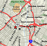
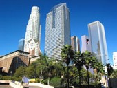
Neighborhoods in Downtown Los Angeles - Despite the relatively recent construction of numerous cultural centers (such as the Walt Disney Concert Hall and Cathedral of Our Lady of the Angels) as well as a handful of trendy restaurants, L.A.'s Downtown isn't the tourist hub that it would be in most cities. However, recent condo conversions of historic downtown buildings and newly constructed loft spaces are attracting more residents to downtown.
El Pueblo de Los Angeles Historic District - This 44-acre ode to the city's early years is well worth a visit.
Chinatown - Located just north of the 101 freeway, surrounding Broadway and Hill streets. It is small and touristy, but can be plenty of fun for souvenir-hunting or traditional dim sum. Many art galleries have moved into Chinatown recently, mostly on pedestrian street Chun-King Road. Gallery walks are held every month.
Griffith Park - Up Western Avenue in the northernmost part of Hollywood, this is one of the country's largest urban parks. It's home to the Los Angeles Zoo, the Griffith Park Observatory, the Autry National Center, and the outdoor Greek Theater.
Neighborhoods in Downtown Los Angeles - Despite the relatively recent construction of numerous cultural centers (such as the Walt Disney Concert Hall and Cathedral of Our Lady of the Angels) as well as a handful of trendy restaurants, L.A.'s Downtown isn't the tourist hub that it would be in most cities. However, recent condo conversions of historic downtown buildings and newly constructed loft spaces are attracting more residents to downtown.
El Pueblo de Los Angeles Historic District - This 44-acre ode to the city's early years is well worth a visit.
Chinatown - Located just north of the 101 freeway, surrounding Broadway and Hill streets. It is small and touristy, but can be plenty of fun for souvenir-hunting or traditional dim sum. Many art galleries have moved into Chinatown recently, mostly on pedestrian street Chun-King Road. Gallery walks are held every month.
Little Tokyo - A gathering place for the Southern California's Japanese population. Includes a wide array of shops and restaurants with an authentic Japanese flair. The Geffen Contemporary (a branch of LA's Museum of Contemporary Art) and the Japanese American National Museum are both located at the corner of Temple and First Streets.
Silver Lake/Los Feliz - Residential neighborhoods just north of downtown. These artsy communities include unique cafes, theaters, and art galleries, as well as a thriving music and club scene.
The San Fernando Valley - Known locally as "The Valley." Located between the Santa Monica and the San Gabriel mountain ranges. Most of the Valley is residential and commercial with a few television and film studios, located in Burbank and Glendale.
|
||||||||||||||||||||||||||||