|
How many terms are in TGN? Tell me about the scope, contributions, and how to obtain TGN data.
Thousands of TGN place records are added and edited every year. As of Augusst 2024, TGN contains 3,020,110 records (5,327,280 place names/terms).
TGN is not comprehensive; although coverage is multilingual and global, scope is tailored to the needs of the Getty Vocabularies' core audience. The scope of TGN includes names, relationships, place types, dates, coordinates, and other rich data for the places required to catalog, discover, and retrieve information about art, architecture, and other visual cultural heritage, including related disciplines dealing with visual works, such as archaeology and conservation. Visual works include not only works classified as art according to Western aesthetics, but also utilitarian and ceremonial works. For works' information, TGN is used for current location, creation location, discovery location, and subject depicted. For people in ULAN, TGN is used for places of birth, death, and activity. TGN is linked to location references in CONA and IA as well. Development in TGN focuses on the historical world, including historical information for extant places and new information about former places. Types of places in TGN include cities, other settlements, nations, empires, archaeological sites, lost settlements, and some physical features. Alternative names for modern places are included, such as indigenous names and historical names. In efforts to provide inclusive and unbiased access, certain historical names are being deprecated and flagged as avoid use.
TGN and the other Getty Vocabularies are unique in their global coverage of the defined domain, in citing published sources and contributors and their preferences, in allowing interconnections among historical and current information, in accommodating the sometimes debated and ambiguous nature of art historical information, and in allowing complex relationships within and between Vocabularies. That is, they are not simple 'value vocabularies'; they are also rich 'knowledge bases' in themselves.
Read more about Scope and Structure of the TGN, including information about what is excluded from TGN.
Contributions:
Getty Vocabularies are compiled resources that grow through contributions from the expert user community comprising various Getty projects and outside institutions; please see our Contributions page. Contributors to the Getty Vocabularies include museums, special collections, visual resources collections, art libraries, archives, bibliographic and documentation projects, large translation projects, and individual experts and scholars A list of contributors is available on this site.
Obtaining the data: The Getty Vocabulary data can be obtained a) on the Getty Web site, free of charge, for searching and displaying individual records, b) by accessing Linked Open Data (LOD), XML, relational tables, and APIs. Read about Obtaining the data. All formats are provided by the J. Paul Getty Trust under the Open Data Commons Attribution License (ODC-By) 1.0. The data in the online Search is refreshed every month. Other formats are refreshed throughout the year.
Who is the audience for TGN?
The intended core audience for TGN are the visual arts and scholarly communities. Included are catalogers, researchers, and developers who seek to provide access to materials concerning the history and context for visual arts and other cultural heritage. Researchers may utilize TGN's place names and rich contextual information about places, globally and throughout history, to enable meaningful research and discovery about visual arts.
Does TGN have maps? Is TGN a GIS?
On the Getty site, TGN is not currently linked to maps, although the coordinates
would allow you to find the places on a map. Various users' applications use TGN linked to maps. Note that TGN is not a GIS (Geographic Information System). It is a thesaurus.
While many records in TGN include coordinates, these coordinates
are approximate and are intended for reference ("finding purposes")
only. TGN is intended to aid cataloging, research, and discovery of art historical, architectural, archaeological, and other scholarly information. However, its thesaural structure and emphasis on historical places makes it useful for other disciplines in the broader Linked Open Data cloud. To combine TGN with GIS information, TGN may be linked through coreferences to existing major, general-purpose, geographic databases.
How much information is required to identify a place in TGN?
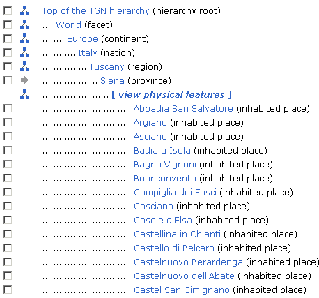
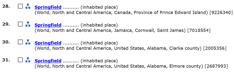
The logical focus of a record in TGN is a place. Although most records contain links and other rich data, the minimum record for each place includes a name, a place type, and a position in the hierarchy that shows its parent places (or broader contexts). In results displays and for matching, the name alone does not identify a place because there may be many homographs in TGN. For example, there are 145 inhabited places called Springfield, including the four below (from a Results List in TGN online). Note that recording the US state Alabama and nation alone would not identify the places; for many nations, the second-level subdivision, such as "county," is required to disambiguate the multiple Springfields.
|
|
Wouldn't latitude and longitude uniquely identify a place? The answer is "no." Single point latitute-longitude data is often quite variable in the way it is determined. Single-point latitude and longitude for an inhabited place or physical feature may represent the approximate center of the place, or the location of the courthouse in a town. For a river or other linear feature, the point may represent the source of the feature, which can be variably estimated. Bounding boxes or other more complex sets of coordinates also can vary from source to source. Thus, while the coordinates may assist in locating the place on a map, or in narrowing down possibilities in matching between data sets, variations in the determination of and expression of coordinates mean that these data cannot uniquely identify places in TGN.
Geographic coordinates indicate the point on the globe where the place is located, expressed in degrees/minutes/seconds and decimal fractions of degrees. They are supplied by contributors, copied from atlases, or loaded from authoritative online resources such as NGA. So far as is possible given that TGN is compiled from various contributors, coordinates in TGN strive to be compliant with following standards: ISO 6709:2008 Standard representation of geographic point location by coordinates, using the WGS 84 coordinate reference system. More information is available in TGN Editorial Guidelines: Coordinates.
Choosing among homographs: For end users, the name plus string of parents plus place type are usually sufficient to manually choose between homographs.
Siena (province) (Europe, Italy, Tuscany) [7003168]
Siena (inhabited place) (Europe, Italy, Tuscany, Siena province) [7011179]
Read about TGN Editorial Rules: Label.
For implementations of the data, developers could organize results lists and aid linking in an open environment by using the "Noted" flag. For certain places having names that are homographs, the record (TGN subject_id) most likely to be intended among homographs is flagged. The field called Comment will contain the value "Noted" when this record represents the place to which most references should link if no broader context is provided. Typically, this "Noted" place is the one that is most famous, largest, or otherwise most often referenced in art historical literature. For example, if a resource refers to a place as simply London with no broader context, it can be assumed it means the London in England. London, England, TGN_7011781 is flagged as "Noted" in TGN to aid in such matches. London TGN_7013066 in Ontario, Canada is not flagged "Noted."
What are the relationships in TGN?
TGN is a thesaurus. The defining characteristic of a thesaurus, that which distinguishes it from a flat list of names such as a glossary, is the network of relationships among its names/terms and concepts. These relationships are semantic relationships, based on logical connections among the sites, towns, nations, kingdoms, etc. represented by the names/terms. Thesaurus construction standards identify three kinds of relationships, all of which are included in TGN: Equivalence, Hierarchical, and Associative relationships.
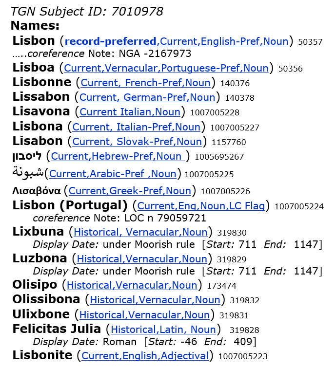
- Equivalence Relationship. Multiple names may refer to the same place. The relationship between names that represent the same place is the equivalence relationship. Among names that refer to a single place, one is chosen as the record-preferred name. This is usually the current name in the vernacular language of the place, in the Roman alphabet and as found in English-language scholarly or professional sources. Other names for the place are synonyms, including historical names, variant spellings, names in English or other languages, inverted forms of multi-word names, or names that are parts of speech other than nouns (such as adjectival forms).
Each name in the record (i.e., "subject_id") is identified by its own unique identifier, the "term id." Users may choose or link to any name/term in the record. For example, in a historical context, a museum may wish to link to the historical name appropriate for the place in the timeframe being discussed, since the modern name will appear anachronistic and incorrect to their users.
Some users will wish or need to consistently use the same name for a given place in all circumstances. They may choose the Record-Preferred name, which is a default name usually comprising the vernacular name as found in English-language sources. However, for continents and certain other places, the record-preferred name is the English-preferred name. The special Vernacular Flag may also be used for this purpose. In the TGN online search, if you set the display at upper right to "Vernacular", the hierarchies will display according to this logic. Setting this display to "English" instead of "Vernacular" will cause the hierarchy to display with the English-preferred name, if any; if none, the Vernacular name is used. In the data files, the separate "Vernacular Flag" may be used to distinguish these names.
Users could also use other flags to identify a name consistently. They could choose the Preferred name for another language, historical or current names, the preferred name according to a given published source or according to a particular contributor. The Library of Congress preferred name, as used in LOC headings, if any, is picked out also by a special flag, the "LC flag" (also called "AACR flag").
In the example below, all names refer to the same city, Lisbon, Portugal.
Variant and alternate names in the record include names in other languages, names transliterated into the Roman alphabet by various methods, names in natural or inverted form (particularly for physical features, e.g., Etna, Mount), nicknames, official names, and historical names. Misspellings may be included if they are found in published sources.
- Hierarchical Relationship. The hierarchy in the TGN refers to the method of structuring and displaying the places within their broader contexts. Hierarchical relationships in TGN represent whole/part relationships and are typically indicated with indention, as in the example below.
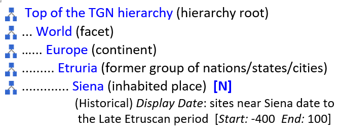
TGN is polyhierarchical, meaning that a place record (subject_id) may have multiple parents (broader contexts). Multiple parents are common for places that throughout history were part of (narrower context of) multiple states. In the modern world, places may also have multiple parents. For example, the US state of Hawaii is administratively part of the United States in North America, but it is physically located in Oceania. It is linked to both hierarchies. Below is an example of a historical relationship: Siena (today in Tuscany, Italy) is displayed as part of the ancient confederation of Etruria. The historical relationship is indicated with an [N] for "Non-preferred" (because the current hierarchical relationship for Siena as part of modern Italy is the default record-Preferred relationship).
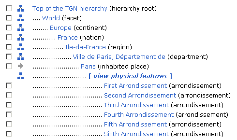
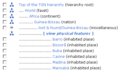
The hierarchies of TGN typically emphasize the administrative configuration of the world, arranged by continent, nation, first level subdivision, second level subdivision, and inhabited place. In addition to the hierachical broader/narrower (whole/part) links, these major administrative levels may be recognized in the data releases by their Place Types. For a discussion of how to recognize or use these Place Types to organize a display of the administrative hierachies, see TGN Editorial Rules: Hierarchical Relationships. Siblings in a branch of the hierarchy are generally arranged alphabetically. However, when necessary, the sort order of siblings may be forced. In the example below, the subdivisions of the inhabited place are arranged in a logical order that is numeric rather than alphabetical. In the Getty online hierarchical displays of TGN, the physical features are separated from the administrative entities. To display the physical features under Paris in the example below, the user would click on "[view physical features]." In the data, these broad entity types are flagged by the Record Type element, "Administrative" and "Physical feature."
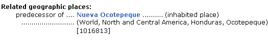
- Associative Relationship. Associative relationships are relationships between entities in a thesaurus, where the relationship is not hierarchical. In TGN, associative relationships could include important historical ally relationships, places requiring special distinguishment to avoid confusion, historical predecessors for modern counterparts, among others. For example, if an inhabited place has been physically moved (as when the location has been deemed unsafe due to flood or earthquake), there should be an associative relationship between the original settlement and the new settlement. In the example below, for the record for Ocotepeque, Honduras, the town was originally located to the NE of the current city, but was moved after the Marchala river flooded in 1935. The new town is called Nueva Ocotepeque. Relationship Types are controlled and defined; see Relationship Types in the Editorial Rules. Associative Relationships are reciprocal between the two records.
Are dates included for places in TGN?
Dates for names or place types in TGN are expressed in notes called Display Dates, which are indexed with Start Date and End Date containing the two years delimiting the implied span. In the Display Date, uncertainty and nuance may be expressed. Since conventions used to describe approximate dates (e.g., circa) may vary depending upon context, this method allows flexibility in establishing appropriate date spans for retrieval. Note that Start Date and End Date are recorded in the database, but generally should be hidden from the typical end user.
|
|
|
(for an island, the, exact date of naming is documented)
Christmas Island (record-preferred,Current,English-Pref)
Display Date: named for Christmas Day, in 1643
[Start: 1643, End: 9999]
(for a US state, estimated start and end dates for "circa")
Indiana (Current,English-Pref)
Display Date: named by land developers ca. 1765, meaning "land of the American Indians"
[Start: 1750, End: 9999]
(for Siena, Italy, historical name with start date based on life dates of Julius Caesar)
Saena Julia (Historical,Latin)
Display Date: Roman, reference to Julius Caesar
[Start: -100, End: 300]
|
|
|
Where may I find detailed information about fields and editorial policy?
You may consult online extensive discussions of the fields and Editorial Guidelines.
For translation work in the AAT, please see Guidelines for Multilingual Equivalency Work.
A training presentation on Introduction to TGN gives a basic overview. Additional materials on Getty Vocabularies Training page are available.
How does TGN handle cases where the broader context of a place is unknown?
General TGN editorial policy dictates that place records are published only when it is possible to determine their correct hierarchical position. However, in practical application, there must be exceptions. For example, information about the internal subdivisions of a nation may be in flux or unavailable. Other exceptions exist. In such cases, the records may temporarily appear under a Guide Term level (called lost & found), as in the example below.
Why and how do TGN records and names
change over time?
TGN data changes as necessary with additions of new data and due to changes in scholarship or usage over time. Although additions are frequent, substantive changes to preferred terms and hierarchical structure are rare, given that such changes could cause problems for users who rely upon legacy data. The unique subject_ids and term_ids, along with the Revision History, allow implementers to keep up with changes.
TGN records are changed primarily for these reasons:
- Loading contributions that require additions or changes.
- To add new records (called "subjects" in the database)
or to add new names to existing subjects.
- To reflect changes in scholarship or usage of names, their
definitions, or scope of the entity represented.
- To make the data more consistent throughout. Legacy data and incoming
contributed datasets occasionally require changes to existing records
in order to maintain the logic and consistency of the whole.
- To place subjects in new hierarchical arrangements, historical or current. .
- To correct outright mistakes, either arising from anomolies in loaded data, in contributors'
data, or due to editor error.
The Getty Vocabulary Program has a very small staff. We rely upon the user community
to grow the TGN. We also welcome users pointing out errors or inconsistencies.
Go to the general F.A.Q. for the Getty Vocabularies.
|
|